Five Rivers MetroParks Adventure Summit

Friday and Saturday, February 14 and 15 at the Wright State University Student Center Five Rivers MetroParks is sponsoring their annual Adventure Summit. There will be over 60 presentations and workshops on everything from hiking the Appalachian Trail to canoeing Canada.  You can get active with fitness programs, kayaking, bouldering, stand up paddleboarding, SCUBA and skin diving. There will also be bouldering competitions, a Frosty Cheeks 5k, indoor triathlon, canoe battleship, and kayak polo. Food and beverages are available including free beer tastings throughout the day.

Friday night’s keynote speaker at 8:00pm will be Dave Cornthwaite the founder of Expedition 1000: 25 unique and non-motorized journeys of 1000 miles or more. He will be talking on the philosophy of adventure. Saturday’s keynote speaker at 12:30pm will be Jon Turk Long distance sea kayaker, awarded “Expedition of the Year” by Canoe and Kayak Magazine. His talk is entitled, “Crocodiles and Ice”.

See you all there!

Posted in Uncategorized | Leave a comment

Little Miami River Celebration: Saturday, June 26th

The Narrows Reserve at 2575 Indian Ripple Rd., Beavercreek. Ohio 45440 will be hosting the Little Miami River Celebration Saturday, June 26th from 9:30 AM until 2:00 PM. The event is sponsored by Greene County Parks and Recreation.

ODNR Division of Watercraft, ODNR Division of Wildlife, Rivers Edge Outfitters and others will be participating. You can learn how to fly fish, see the newest in canoes and kayaks. There are many other events planned for the day.

If you are looking for a quiet day to hike in the Reserve, obviously this is not it, but there will be plenty of family friendly activities.

Posted in Canoeing, Fishing, Greene County, Hiking | Tagged , | Leave a comment

Are Trekking Poles a Good Idea?

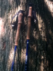
Trekking Poles

Trekking Poles

Trekking poles or “walking sticks” have been a great idea for me. I‘ve owned trekking poles for at least ten years. I used them a little when I first got them, but didn’t really understand the advantage. About a year ago my knees, which have been giving me trouble for going on thirty years, really started to bark. I was wondering if I was going to have to cut my hiking way back.

Trekking Poles Reduce Joint Impact
I remembered reading something that said trekking poles could reduce the impact of hiking on the knees 20% to 25%. There were actually two studies showing the benefit of poles.  In 1981 Dr. G. Neureuther proved that “ski poles” reduced the pressure or strain on the opposite leg by about 20%. A 1999 study in the Journal of Sports Medicine showed trekking poles can reduce the compressive force on your knees by up to 25%.

I don’t know if you will have the same success as I have, but it was almost instantaneous for me. Don’t use the poles, knees hurt. Use the poles, pain relief. I recommend them to everyone. I don’t know how much wear and tear I would have saved my knees if I had used them years ago. Another benefit for me personally was my shoulders. I was having some shoulder problems and using the poles helped strengthen my shoulders. The other benefit was that waddle you get under the biceps. Helped tighten mine right up.

Advantages of Trekking Poles
Trekking poles do offer advantages that, I know, will help everyone:

  • Better balance and footing
  • Help you set a pace
  • Move vegetation off trail
  • Probing unknown surfaces and holes

Aluminium or Graphite?
Trekking poles are made of either aluminum or graphite. Aluminum will handle shock better. Graphite will be lighter. Graphite will also make your wallet lighter. Graphite is more expensive. Since trekking poles have become more mainstream, you can find them at most larger sporting goods stores as well as hiking and backpacking stores. There are a number of online sellers as well. I just happened to buy mine at Sierra Trading Post. They sell overruns and seconds at a reduced price. I have had no trouble with mine.

Cork, Rubber or Foam Handles?
The handles are made of cork, rubber, and foam. My poles just happen to be made

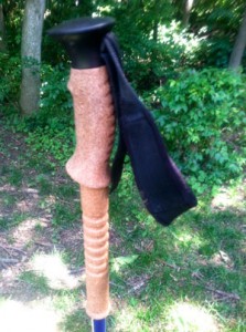
Cork Handles

Cork Handles

of cork. Cork is the traditional material for trekking poles. Cork resists moisture from sweaty hands and molds to your hands well. Unfortunately, it is the most expensive.

Rubber handles are best for poles used in cold weather since it is a good insulator. A buddy of mine has rubber handles and they get a little slimy in the warmer weather, but it is not a big negative for him.

Foam handles are softest to the touch and absorb moisture from sweaty hands. I have no experience with foam. My biggest concern is durability. When they are dropped does the foam get nicked up? If you have experience with foam let me know and I will post your experience.

The pictures you see are of my trekking poles. The only reason I have cork is because my poles are so old. I don’t know if I would have spent the extra money today. As you can see the cork handles have the extensions below the handle for uneven terrain. Can’t say I have ever used the lower section of the handles. Does anyone see them as a great advantage?

Fitting Your Poles
My poles have twist locks to lengthen and shorten the poles. I have never had

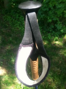
Handle ans Strap

Handle and Strap

any problem with them. My buddy has flip locks to control the length of his poles. His also have a nut that he can adjust the tension of the locks. Does anyone have any preferences?

If you have never used poles before it is pretty simple. Adjust the poles to a length that makes your forearm parallel to the ground with your elbow at a 90-degree angle (see picture).

You will see in various places people recommending you shorten your poles on uphill terrain and lengthen them on downhill to maintain that 90-degree angle. Unless you are going uphill or downhill all day I don’t see the advantage of continual switching…too much work… too much time. Just my opinion.

Your trekking pole may be made up of two or three section. If it is a two section it

Handle and Strap View Two

Strap Padding

is simple, just set the length. If it is a three-section pole you want each section to be about the same length to make it its strongest. Most poles will give the overall length of the pole, at each joint, to make it easy to get the pole sections even. Check you manufacturers instructions for precise fitting instructions.


How Do I Hold the Poles?
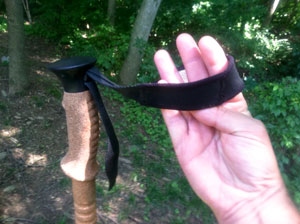
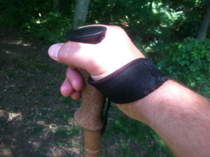
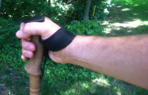
Holding the pole may be a little counter intuitive.You use the strap to hold the pole and swing it forward. Using your thumb and first finger like a clip. To get your hand in the right position put your hand up through the strap and grasp the pole with the piece of strap attached to the pole between your hand and the pole. Your wrist and hand will bear the pressure of using the pole, rather than grasping it like an upside down tennis racquet.

Grasping the pole sounds more complicated than it is, see the pictures for

Put Hand Up Through Strap

Put Hand Up Through Strap

better clarity. You use the strap as a pivot point to allow you to flip the poles out infront of you as you move down the trail.  The pole out in front will be opposite the forward foot.


Easy to Adjust Strap
When you buy your poles make sure the strap is easy to adjust. In winter you will need to make the loop bigger to fit around your gloves and smaller in the summer. My strap has a nice wide padded section that will help spread the pressure of planting the pole.

There are pluses and minuses to the padding. Due to sweating the strap can start

Hand Over Strap Onto Handle

Hand Over Strap Onto Handle

to smell like an old pair of sneakers. I found soaking them in OxiClean over night should solve the problem. You just have to figure out how to prop your poles so the straps can drop into a container containing the solution.


There are some environmental concerns with using poles. The tips can scratch stone, so you might leave a mark. There are rubber tips that you can put over the metal ones to keep you from scratching rock and they actually might give you better traction. Be careful with the poles on wet or icy mornings on bridges. Pressure treated lumber is great for lasting a

Forearm Parallel to Ground, Elbow 90-degrees

Forearm Parallel to Ground, Elbow 90-degrees

long time, but it gets real slimy and the poles won’t help you much in this situation.


You will probably come upon some people that don’t understand why you use your trekking poles, but I would not let that deter you. I wish I had the foresight to understand how much they could have helped me years ago.


Posted in Gear, Hiking, Safety | Tagged , | Leave a comment

Hiking Sugar Creek MetroPark

Sugar Creek MetroPark

Sugar Creek MetroPark

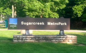
Sugarcreek Metropark, 4178 Conference Road, Bellbrook, Ohio 45305 is a diverse habitat with everything from a meadow to rolling hills. Two of its premier attractions are 550 plus year old oaks (one group known as the “Three Sisters” unfortunately there are only two remaining) and an Osage Orange Tunnel.

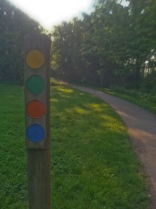
The trails are well marked, wide and road like, which is a good thing since it is one of the most heavily used parks in the area. It is a favorite of runners and hikers alike. On a weekend or holiday you probably will never feel alone. The park is dog friendly, but does require a lease. The trails are all loops, so it is easy to find your way around once get accustomed to the dotted trail markers.

Trail Marker

Trail Marker

It is possible to get confused when hiking the park. I have had more than one person ask me which way is out. The part that gets most people is the trails overlap which means there will be markers with more than one colored dot. Just remember when you come to an intersection look behind you, ahead of you, and down the trail that intersects for the color you are following. This will help you figure out if you need to make the turn or keep going.

There are also numbers at the various trail intersections to help in navigation of the park. There are paper maps available at the park or online and there are maps strategically placed on the trails. Not having a map should not deter you from hiking the park. Common sense and a general feeling what direction you are going should be enough. If you get confused just ask someone, there should be plenty of people around.

The Montgomery County Park District (MetroParks) operates and maintains Sugarcreek MetroPark. I am not sure you will find too many parks owned and operated by one county, but located in a different county. The reason for this anomaly is by the time the park district was formed land prices in the portion of the county the park was meant to serve were beyond the its means, so land was sought in adjacent Greene County. The park was made up of two major land purchases in the mid sixties. The land was last farmed in 1968.

There are five primary trails varying in length from 3.1 miles to .07 miles in length. The trails run from easy to moderate. There are some steep areas that some might describe as difficult. There is only a little more than 100 feet of elevation gain or lose on the trails.  There are two other trails: 1) a .25 mile asphalt handicapped accessible trail in the meadow, and 2) the Big Woods Trail which is across the Little Sugar Creek off of the Green trail.  The asphalt wheel chair accessible trail is just to the right after you take the short walk from the parking lot to the main distribution point for all the trails.

Trail Length and difficulty

  • Osage Orange Tunnel

    Orange Trail's Osage Orange Tunnel

    Green Trail  ∙ 3.1 miles ∙ moderate (many changes in elevation, one longer up if you follow loop counterclockwise)

  • Orange Trail ∙ 1.3 miles ∙ easy (little elevation change)
  • Blue Trail ∙ 1.2 miles ∙ moderate (one very steep up if you follow the trail counterclockwise)
  • Red Trail ∙ 0.8 miles ∙ easy (little elevation change)
  • Yellow Trail ∙ 0.7 miles ∙ easy (mostly flat)
  • Big Woods Trail ∙ 1.0 miles ∙ easy to moderate (some elevation gain and lose)
  • Handicap Accessible Trail ∙ .25 miles (flat)

Green Trail
The Green Trail is the longest loop in the park taking you by or through most of the various habitats in the park. If you take the trail counterclockwise you will travel along a large meadow which is actually a planted prairie. Depending on the time of year you are at the park the prairie grass will be low because the park does a burn to maintain the prairie. In the late summer the grass will be almost head high. The rest of the trek on the Green Trail will be in the woods.

At marker 9 there is a side trail that will take you across Sugar Creek and on to Spring Lakes Park. Spring Lakes are ponds stocked by the Greene County Park District. Your regular state fishing license is no good here. You will need Greene County fishing permit. There is self registration for fishing licensees at the park. The lakes are stocked once per month with trout October through February and catfish March through September.

At marker 16 you can drop down and head across Sugar Creek again and hit the Big Woods Trail. The trail runs along the creek for a little ways and then you will enter a loop that will bring you back. It’s a nice quiet little trail that can get you off the hubbub of the main trails.

In the winter time the section of the Green Trail (it’s also the Blue Trail) that runs along Sugar Creek can be icy. The area being low keeps it pretty shaded. Combine the shade and all the water running down the hill into the creek it takes a pretty good stretch of warm temperatures to clear the ice and snow. It is passable, but you need to watch your step.

Three Sisters

Three Sisters in Winter. The middle sister is now gone.

Orange Trail
The Orange Trail has two of the most interesting attractions you will see anywhere. First are the “Three Sisters.”  The sisters are 550 plus year old white oak trees. They are something to see. Unfortunately, now there are only two of the sisters left. The park district is starting to talk about them as just “the Sisters,” but they will always be the three sisters to me.

The second attraction on the Orange Trail is the Osage Orange Tunnel. In the late 1800”s there were companies selling a “living fence.” The company would prepare the ground, plant the plants, and then trim them until a perfect hedge was formed. The Osage Orange plants left to grow on their own eventually get big enough when they are not maintained turn into a natural tunnel. It creates a cool oasis and is kind of relaxing.

Blue and Red Trails
The Blue and Red Trail cover a lot of the same ground. The Blue Trail has the distinction of having the longest steepest section of any of the trails. The up is not terribly long, but you will probably be breathing hard by the top. The up part of the trail has uneven stone stairs which adds to its challenging nature. If you want to go down the steep section, follow the trail counterclockwise. The Red Trail is a rather nondescript walk through the woods except for the unusual stand of Sycamore trees on the ridge. Sycamores are water lovers, so you usually see them by waterways. There must me some very unusual water source on that ridge to keep those trees happy. The Sycamores should be easy to spot they have the bark that looks like camouflage.

Planted Praire

Planted Prairie in Spring

Yellow Trail
The Yellow Trail loops through the planted prairie. It can be kind of hot out there in the summer time with no shade. One of the interesting parts of the trail is seeing the various grassland birds like red-winged blackbirds, bluebirds, and indigo buntings to name a few.

I have hiked Sugar Creek MetroPark since the 1970’s when it was little more than some old farm roads and narrow paths through a couple of old farms. It has sure grown up over the years. Most of the trails are more road-like now and with the amount of traffic the park gets it’s pretty much a necessity.

The park is a big favorite of runners. You will see them almost every time you hit the trail. In June there is the Sugarcreek 5 miler sponsored by the Ohio River Runners Club and the Dirty Dude Girl Trail Run sponsored by Up and Running.  Up and Running also sponsors weekly 8:00AM Sunday morning runs at the Park.

I really like Sugar Creek, but I try to time my visits other than weekends and holidays. There are just too many people. I recommend weekdays early and the winter time to visit the “Three Sisters” and the Osage Orange Tunnel.

Posted in Fishing, Greene County, Hiking, Montgomery County, Running | Tagged | Leave a comment

Hocking Hills State Park

Hocking Hills Area

Hocking Hills Area (Click on Map for Enlarged View)

The Hocking Hills area, in southeastern Ohio, has some of the most beautiful and interesting parks you will find in Ohio. It amazes me how many people have never heard of Ash Cave, Cantwell Cliffs, Cedar Falls, Conkle’s Hollow, Old Man’s Cave, and Rock House these beautiful areas carved by water and wind over the millennium.

I took a bunch of Boy Scouts to Hocking Hills and hiked from Old Man’s Cave to Cedar Falls and back. I explained to them how the water eroded the sandstone gorge creating the beauty we were seeing. One young scout just couldn’t comprehend how this had all happened naturally over time and he said to me, “Now who built this?” He was pretty sure Disney or someone had come in and done the job. I reassured him even as good as Disney was, only nature could build something this nice.

Area Maps
The best thing about the various parks is almost everyone can enjoy them since most of them are relatively easy to reach. Ash Cave and Conkle’s Hollow are wheelchair accessible. Following is a guide to length and difficulty.

Click the name above for area maps of all the attractions. The number of stair-steps is even marked to help you decide if this trail is for you.

My favorite day hike is to go from Old Man’s Cave to Cedar Falls to Ash Cave and back. There are a few spots where there are some stairs that could be deemed difficult by some, but I found most of it moderate to easy. The Buckeye Trail people have a page on their website describing the hike. According to their website you can do it in two ways, either 6 or 10 miles. It is a great hike, sometimes at the falls and at the cave there can be a lot of people. The trail between the two is usually pretty quiet. It will be worth your while to check with a ranger to make sure the trail from Old Man’s Cave to Cedar Falls is passable. During certain times of the year a lot of water can move through the gorge washing away bridges and knocking down trees.
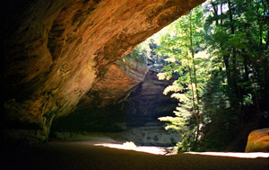
Ash Cave

Ash Cave

Ash Cave
Old Man’s Cave is the most visited of the parks, but my favorite is Ash Cave. There is something about its majesty and size.  Sitting back under the rim gives me a real peaceful feeling. Ash Cave is 700 feet long, 100 feet front to back, with the rim 90 feet above. A beautiful little waterfall cascades from the rim. The cave was named for the large pile of ashes that was found under the rim from Indian campfires built up over hundreds of years. Some believe the Indians were smelting silver or lead others claim they were making saltpeter. Ash Cave is wheelchair accessible.

Cantwell Cliffs
Cantwell Cliffs is probably the least visited of the group because its location is remote from the rest. Many people believe this is the most picturesque in Hocking County. Personally, I think they all have their own unique qualities. Its trails may be the most challenging. Try to get through “Fat Woman’s Squeeze.”
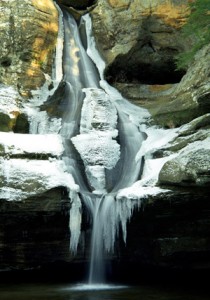
Cedar Falls in Winter

Cedar Falls in Winter

Cedar Falls
Cedar Falls is a fifty foot water fall. It is the largest waterfall, by volume, in Hocking Hills State Park. The falls usually runs year round. The falls were misnamed by the early settlers. They thought the surrounding eastern hemlocks were cedars. It is one of the most popular attractions in Hocking County.

It is a relatively short hike to Ash Cave from the falls. Additionally, you can hike to Old Man’s Cave from the falls. These trails are a part of the Ohio Buckeye Trail.  This six-mile section of the Buckeye Trail at Cedar Falls Ohio, also known as the Grandma Gatewood Trail, is part of two national trails: the North Country Scenic Trail and the American Discovery Trail.

There is an interesting bridge below Cedar Falls called “Bent Bridge.”  This bridge was originally straight, but during high water downed trees rammed the bridge bending the steel girders. Extensive repair and modernization was done in the gorge in 2002-2003. The bridge was repaired, but was left with the familiar curve.

At one time there was a grist mill at the top of the falls. From the bridge at the top of the falls, if you look closely at the stream remnants of the old mill can be seen. The grist stones by the Bent bridge are from the old mill.

Conkle’s Hollow
Conkle’s  Hollow is known for its Blackhand sandstone cliffs that rise 200 feet above the valley floor. The cliffs are quite spectacular, but I love the Conkle’s Hollow gorge for the ferns and peaceful feeling it gives you. The gorge is only 100 feet wide in places and has a number of waterfalls. Conkle’s Hollow is named after an early German immigrant W.J. Conkle who was an early visitor to the ravine. In 1797, Conkle carved his name into the west side of the cliff and settled nearby.

There are a couple of legends about Conkle’s Hollow. The first on says there is still treasure hidden in the cliffs that Native Americans placed there, but could not retrieve because the tree  they were going to use as a ladder fell down so there was no way to reach the loot. Supposedly there is an arrow carved in an eastern wall pointing to the loot. The other story also pertains to some Native Americans. It was said they stole some loot from some settlers traveling in the area. They were captured and hung for their crimes in the hollow. The story is you can still see their shadows roaming up and down the trails.

Click here for a nice brochure the Division of Natural Areas and Preserves put together on Conkle’s Hollow history and geology. Part of the trail is wheelchair accessible.

Climbing Area
For climbers, just a little farther down the road from Conkle’s Hollow on Big Pine Road is a state-owned climbing area. The climbing area features about one mile of cliffs up to 120 feet tall. There are also fallen house-sized boulders, cracks, chimneys and overhangs.
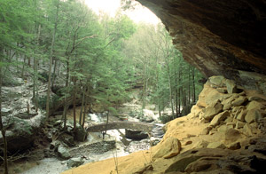
View From Old Man's Cave into Gorge

View From Old Man's Cave into Gorge

Old Man’s Cave
Old Man’s Cave is the most popular of the six major areas of Hocking Hills State Park. Old Man’s Cave was named for an early settler, Richard Rowe. Rowe had set up living quarters in one of the many recess caves in the area after the Civil War. Killed by an accidental blast of his own gun, it is said local native Indians buried him somewhere near the entrance of the Cave.

The gorge at Old Man’s Cave is about a mile long with multiple waterfalls, sandstone cliffs and rock formations with names like the Devil’s Bathtub, Sphinx Head, Eagle Rock and Whale in the Wall. Old Man’s Cave is also home to the 149-foot-tall hemlock that’s said to be the tallest tree in Ohio.

There are five main sections carved by Old Man’s Creek that runs through the gorge: Upper Falls, Upper Gorge, Middle Falls, Lower Falls and Lower Gorge. The Grandma Gatewood Trail —a six-mile stretch of Ohio’s Buckeye Trail — begins at Upper Falls and leads from Old Man’s Cave Ohio to Cedar Falls and Ash Cave, two other areas within Hocking Hills State Park. The Grandma Gatewood Trail is also part of two national trails: the North Country Scenic Trail and the American Discovery Trail as well as the Ohio Buckeye Trail.
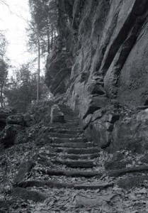
Stairs to Rock House

Stairs to Rock House

Rock House
Rock House is unique in the Hocking Hills’ region, as it is the only true cave in the park as well as having a very colorful past. The trail to the Rock House is a bit more challenging than most of the other trails in Hocking Hills State Park, but I believe you will find it worthwhile to make a visit.

Rock House is a tunnel-like corridor situated midway up a 150-foot cliff of Blackhand sandstone which you see all over the area. The Rock House is complete with seven Gothic-arched windows and great sandstone columns which bear the weight of the roof.

The ceiling is 25 feet high while the main corridor is 200 feet long and 20 to 30 feet wide. Water leaking through a horizontal joint running parallel to the cliff face caused the hollowing of the corridor. This main joint or crack is very visible in the ceiling of the Rock House. A small series of joints run north to south at right angles to the main joint. Enlargement of this series of joints formed the window-like openings of Rock House.

Rock House was used for shelter by past visitors. Hominy holes, small recesses in the rear wall of Rock House, served as baking ovens for Native Americans using the cave. By building a fire in the small recesses, the rock became heated on all sides allowing food could be baked. Chiseled out troughs or holding tanks found in the stone floor were used for water storage. When rainfall is abundant, springs of water permeate the porous sandstone and flow into these troughs and, when full, continue across the floor and out of the windows.

Rock House has long been a popular tourist attraction. In 1835, Colonel F.F. Rempel of Logan erected a 16-room hotel compete with ballroom, livery stable and a U.S. Post Office. The hotel stood where the picnic shelter is today. Numerous dated carvings in the rock bear evidence of this area’s long-standing popularity.

According to local folklore, there were also some not so welcome visitors to Rock House. Robbers, horse thieves, murderers and even bootleggers earned Rock House a reputation as, “Robbers Roost.”

Turpentine was a vital commodity for the Indians. It was used as medicine, both internally (even though today we know that is not a good idea) and externally, for a variety of illnesses and injuries. Inside the Rock House are two “turpentine stills,” left over from the Indian days. The stills are small recesses, or depressions, hand carved on the top surfaces of two sandstone shelves, each with a small channel leading over to the lip of the shelf. The Indians would place bits of pitch pine wood in one of the depressions. A layer of flat sandstone would be placed over the wood, and a fire would be built on top. The heat would drive the sap out of the wood, which would then flow through the channel and pour into a waiting vessel.

In the late 1700’s, the Indians were driven out of the area. The pioneers who moved in and occupied the land had an even bigger need for turpentine than the Indians. Pioneers used the Indian stills, but with a slight change in technology. The pioneers would invert their black, iron kettles over the pine bits, and build the fire on top.

The use of turpentine as medicine for man and beast continued for many years. Turpentine was sold, for medicinal purposes, in pharmacies until the mid-1960’s. Today the only turpentine you will find will be in hardware stores sold as paint thinner.

Winter Hike
The whole Hocking Hills area is really worth the trip. I would highly recommend a winter trip. You definitely have to be careful on your hikes because of all the slippery spots, but the frozen and partly frozen waterfalls are spectacular. You could also catch a break with the number of people you encounter. I would recommend getting there early regardless to cut the number of people you meet. Being there in virtual solitude is priceless.

Posted in Climbing, Hiking, Hocking County | Tagged , , , , , , , | 5 Comments

The Narrows Reserve

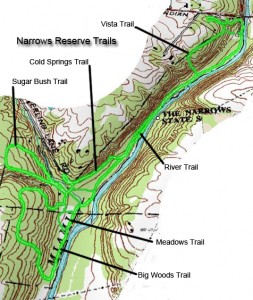
The Narrows Reserve Trail Map

Click on Narrows Reserve Trail Map for Larger View

This is a little gem that I am surprised when people say they don’t know about it or have never been there. The Narrows is run and maintained by the Greene County Park District. The park address is 2575 Indian Ripple Road, Beavercreek, Ohio 45440. It’s easy to find. The entrance is directly across from where Factory Road dead ends into Indian Ripple Road.

It is only a short drive from my house and is my default hiking spot. In total there are about five miles of trails. The main trail runs along the Little Miami State and National Scenic River with five loops. The various trails can be broken down in numerous ways from a completely flat 2.5 mile hike to an easy to moderate 5 mile hike or run. The Narrows is a favorite of runners and is the location of an annual Narrows 5 Miler, in November, sponsored by the Ohio River Road Runners Club (ORRRC). It also has a canoe launch area for the Little Miami River.

Trail Guide: Length and Difficulty
The trails at the Narrows, in general, are easy to moderate in difficulty to hike except for the three trails with steep inclines; the Vista, Sugar Bush, and Big Woods Trails which have difficult sections. Keeping in mind  all of the trails, with difficult sections are loops.  You can reduce the difficulty of the tougher trails by hiking the trail in the opposite direction making the steepest section, a downhill.

Trail length and difficulty

  • River Trail • 1.25 miles • easy
  • Vista Trail (clockwise) • .50 miles • moderate to difficult
  • Vista Trail (counterclockwise) • .50 miles • moderate
  • Cold Springs Trail • .25 miles • easy
  • Sugar Bush Trail (clockwise) • .50 miles • moderate to difficult
  • Sugar Bush Trail (counterclockwise) • .50 miles • moderate
  • Meadow Trail • .25 miles • easy
  • Big Woods Trail (clockwise) • .75 miles • moderate to difficult
  • Big Woods Trail (counterclockwise) • .75 miles • moderate


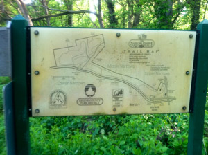
Trail Head Sign

Trail Head Sign and Map

The Trail Head
The trail head is off the parking lot where you will see a sign with a trail map. The trail map is generally correct, but not 100% accurate. The map above is closer to reality. The trail structure looks like a bone. The shaft of the bone is the River Trail. On the north end there is the single loop, the Vista Trail. On the south end are the other four loops. The first one is the Cold Spring Trail which sort of scabs itself onto the main trail. The final three all run off the end of the River Trail on the south end of the park, the Meadow Trail, the Big Woods Trail, and the Sugar Bush Trail. It’s pretty hard to lose your way at the Narrows, but if you get confused just head toward the river and go north (up river, against the flow).

Easiest Long Hike
The trail that runs along the river is appropriately called the River Trail. If you want the easiest hike and want to cover most all of the trails go north (left on the River Trail). This will take you to the first loop on the north end of the park, the Vista Trail.

The middle part of the Vista Trail is a nature trail where there are signs giving you various tree names. The trail also gives you access to the Nature Center, bird rehabilitation shelter, and an apiary. The portion of the trail that runs next to the Nature Center is the old road. It’s kind of hard to imagine that being Indian Ripple Road and heading over the Little Miami River. You can also gain access to the Nature Center directly from Indian Ripple Road.

If you do not want to continue further into the park, as you leave the part of the Vista Trail that that is designated as a nature trail, you will see a stair on the left that takes you back down to the parking lot.

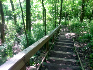
Vista Trail Stairs

Vista Trail Stairs

As you continue into the park, toward the end of the Vista Trail, you will come to a steep hill that has steps and handrail built into the hillside. It’s kind of steep in places, so watch your step. The trail will dump you back onto the River Trail. Left takes you back to the parking lot. Right continues you on your way.

As you walk the River Trail you will see places where the river and flows to the river have changed the trail. The river keeps overflowing its banks causing trees to fall. There are also a number of boardwalks that were built to keep you out of some of the muddier sections of the trail. It is not unusual after hard spring rains when the river overflows its banks to find these boardwalks strewn this way and that at different parts of the trail. As you look away from the river, up the hillsides, you will see where rocks have been washed down across the trail from the water cascading down to the river.

The next turn will be onto the Cold Springs Trail, turn west (right). It will be easy to spot, there is a sign.This trail takes you by an old homestead. If you look carefully you might be able to see the old foundation. You defiantly can see where the old spring comes up out of the ground. Look to the right as you cross the first of two boardwalks. You will see a concrete basin where the spring comes out of the ground. This spring runs year round.  You will see bright green foliage growing in the runoff from the spring even in the winter. On the other side of the trail you can see the outline of what appears to be the remnants of a small pond. It is hard to pick out when all the leaves are on the plants, but is evident in the winter months.

Sperling Lane Cutoff

Cold Spring Turn to Creek Crossing

Continuing south on the Cold Springs Trail you will come to a point where the trail makes a sharp bend to the left with a trail going off to the right. You want to go left. The trail to the right will take you to Sperling Lane and an alternate entrance to the Narrows Reserve.

Almost immediately, as you head down the trail to the left, you will see a trail heading off to the right that crosses the creek. You want to take that trail. It will take you to an old road that will take you to the three loops on the southern portion of the Reserve.

If the creek is too deep to cross you can take the short detour up to Sperling Lane to the alternate park entrance. From this entrance you will follow the old gravel road to access the three loops on the southern end of the Reserve.

If you continue on the Cold Springs Trail it will take you back to the River Trail. When you reach the River Trail you can go left to get back to the parking lot. If you go right you will cross the creek and end up in the meadow where primitive camping is allowed. (Check with the Park District on camping rules.) In the meadow you can access the Meadow Trail and the Big Woods Trail. You can also follow the old road to access the Sugar Bush Trail.

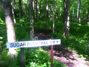
Sugar Bush Trail

Sugar Bush Trail

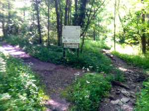
When you reach the old road you want to go right. You will see the sign for the Meadow trail on the left, keep going straight. You will cross the creek and the Sugar Bush Trail will begin/end on either side of the sugar shack. You will see the signs. The Sugar Bush Trail runs through a sugar bush where the sap is harvested and made into maple syrup at the park’s own sugar shack for the annual pancake breakfast. If you go to the left of the sugar shack you will have a steep up a set of stairs built into the hillside. If you would like a little more leisurely hike take the trail starting on the right of the sugar shack. There is a grade, but it is pretty gentle and that allows you to come down the steep section of the trail. If you keep going on the old road it will take you to Sperling Lane and the alternate entrance to the Reserve. If you couldn’t get across the creek this is the way you would come to get to the Sugar Bush Trail.

The Meadow

Entering the Meadow From Big Woods Trail

To continue your hike head back the way you came to the sign that says Meadow Trail. Turn right and about thirty yards ahead you will see the sign for the Big Woods Trail. Turn right onto the Big Woods trail and follow the trail up the hill. This trail has the biggest stand of older trees.  You will also come across an old chimney from a farm house. The trail will loop around and bring you back to the river and the Meadow Trail loop.

Follow the Meadow Trail straight ahead and on the right you will see a sign marking the beginning of the River Trail and the way back to the parking lot. There is a creek crossing that sometimes is too high to wade in boots. So you can either take off your boots or trace your steps back to the meadow and turn right. In about seventy-five yards you will see the trail to the right that you took to originally get across the creek.  It will bring you to the Cold Springs Trail you can go left or right and the loop will take you back to the River Trail. I recommend going left because if the creek is too high to wade, the River Trail will probably be very muddy between the creek and where the northern turn off to the Cold Springs Trail.

A More Challenging Hike
If you want to make the hike a little more challenging simple reverse the start direction of the hike, go right instead of left and finish the hike on the Vista Trail. This will put every one of the steepest parts of the trail in your path.

The Narrows Reserve is also a good place to see wildlife and wild flowers. I run across deer on a regular basis as well as pileated woodpeckers. The spring showing of marsh-marigolds is spectacular and this year there were grape hyacinths everywhere. Since this post is already too long, I will write about the wildlife and wildflowers another time.

Posted in Canoeing, Fishing, Greene County, Hiking, Running | Tagged , | 1 Comment

Welcome

Welcome fellow hiker. I have been hiking around Ohio and nearby states and beyond for almost forty years and I am always surprised when I talk to people about a place I have hiked and they have never been there. With this site I hope to let fellow hikers know about the places I have been, give you ideas of places to go, and anything else I have found that might be of interest.

Welcome aboard and enjoy the ride.


Posted in Uncategorized | 1 Comment